• Video
  • Shop
  • Culture
  • Family
  • Wellness
  • Food
  • Living
  • Style
  • Travel
  • News
  • Book Club
  • Newsletter
  • Privacy Policy
  • Your US State Privacy Rights
  • Children's Online Privacy Policy
  • Interest-Based Ads
  • Terms of Use
  • Do Not Sell My Info
  • Contact Us
  • © 2026 ABC News
  • News

Over 25 million under alert for severe weather, possible flash flooding in Northeast

0:51
Severe weather threat for 25 million
Ishika Samant/Getty Images
ByNadine El-Bawab and Dan Peck
September 06, 2025, 8:55 PM

Strong to severe thunderstorms are sweeping across parts of the Northeast on Saturday afternoon, putting more than 25 million people on alert.

A severe thunderstorm watch has been issued for parts of the Northeast, from Maryland to Maine, until 8 p.m. ET.

This includes much of the Interstate 95 corridor, including Baltimore, Philadelphia, New York City and Boston. 

Spectators cover-up as it rains on Day Fourteen of the 2025 US Open at USTA Billie Jean King National Tennis Center, on Sept. 6, 2025, in New York.
Ishika Samant/Getty Images

The primary hazard from any severe thunderstorms that develop is strong, potentially damaging wind gusts. Isolated large hail and a brief tornado or two cannot be ruled out, especially for locations in northern New England included in the watch.

Any slow-moving thunderstorms with torrential rain could also trigger localized flash flooding, especially in urban, poor-drainage areas, and bring frequent lightning. 

PHOTO: severe weather outlook map
ABC News

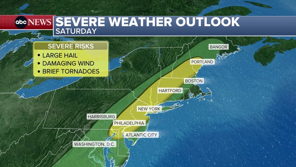
Damaging winds, large hail and lightning will be possible early Saturday evening into the overnight across this area, with a slim risk of a few brief tornadoes.

Flash flooding will also be a concern for some of these areas, with the highest risk (Level 2 of 4) stretching from Philadelphia to Bridgeport, Connecticut.

PHOTO: flash flood threat map
ABC News

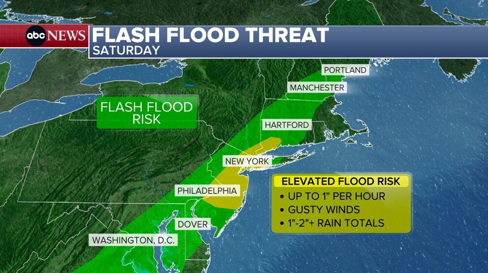
Multiple rounds of heavy rain from overlapping and training storms will be capable of producing localized to scattered areas of flash flooding, especially with the heaviest downpours or in areas known to flood.

The storms are expected to continue into the overnight hours.

Related Articles

Hawaii under state of emergency ahead of Hurricane Kiko

PHOTO: tracking the storms map
ABC News

Cooler air will be sweeping in behind this front, as another round of refreshing, fall-like air moves from the Midwest into the Northeast for the second half of the weekend.

 In true fall-fashion, the cool air will not stick around long, gradually warming is expected throughout next week, from west to east.

Up Next in News—

Gas station clerk speaks out after foiling alleged kidnapping

April 15, 2026

Oklahoma high school principal takes down would-be shooter, hailed as hero

April 15, 2026

Family seeks answers after influencer Ashlee Jenae is found dead on vacation in Tanzania

April 15, 2026

Couple shares warning after nearly losing down payment in mortgage fraud

April 10, 2026

Shop GMA Favorites

ABC will receive a commission for purchases made through these links.

Sponsored Content by Taboola

The latest lifestyle and entertainment news and inspiration for how to live your best life - all from Good Morning America.
  • Contests
  • Terms of Use
  • Privacy Policy
  • Do Not Sell My Info
  • Children’s Online Privacy Policy
  • Advertise with us
  • Your US State Privacy Rights
  • Interest-Based Ads
  • About Nielsen Measurement
  • Press
  • Feedback
  • Shop FAQs
  • ABC News
  • ABC
  • All Videos
  • All Topics
  • Sitemap

© 2026 ABC News
  • Privacy Policy— 
  • Your US State Privacy Rights— 
  • Children's Online Privacy Policy— 
  • Interest-Based Ads— 
  • Terms of Use— 
  • Do Not Sell My Info— 
  • Contact Us— 

© 2026 ABC News