Before and after photos show Hurricane Beryl's destruction on the Gulf Coast of Texas

Before and after photos show the extensive damage done to Texas' Gulf Coast after Hurricane Beryl struck this summer.
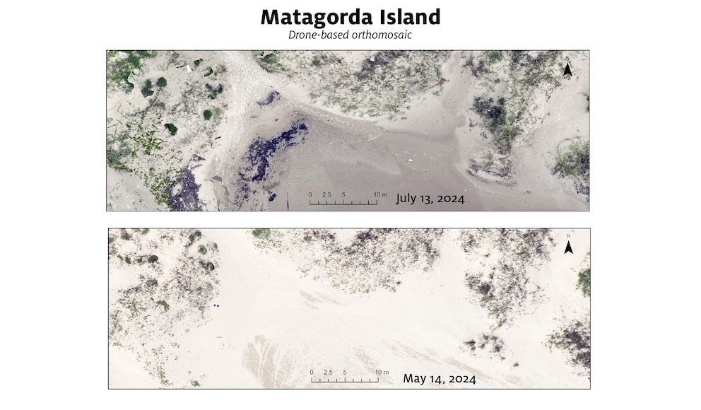
The hurricane, which made landfall near Matagorda, Texas, on July 8 as a Category 1 storm, caused significant destruction on the coastline and barrier islands, Shuhab Khan, a professor of geology at the University of Houston, told ABC News.

Khan is leading a study funded by the National Oceanic and Atmospheric Administration and the Texas General Land Office to quantify the erosion. The ongoing study monitors six key locations on Texas' Gulf Coast every six months: Galveston, Follett's Island, Matagorda, Mustang Island, North Padre Island and Sargent Island.
The researchers used high-resolution light detection and ranging (LIDAR) data to compare the rapid transformation of the beaches where Beryl made landfall.
Images taken in May juxtaposed to images taken in July show the impact the storm had on the beaches and dunes, Khan said.

One of the most heavily impacted areas was Sargent Island, which was "unrecognizable" after Beryl, Khan said. The flooding, overwash and scarping from the storm wiped out nearly all the dunes and left the area virtually inaccessible, the research found.
Beryl caused so much erosion on Sargent Island that it created channels of seawater that flowed from one side of the island to the other, Khan said. All of the dunes and vegetation were decimated as well, and the island was only accessible by boat.
"The island is now connected to the two sides of the ocean," Khan said.

Follett's Island, the location of a restored dune system, was also hit hard, Khan said. The storm swept away most of the sand on the beach, leaving behind bare hay bales that were previously filled with sand, he said.
"When the hurricane hit that area, all the sand and vegetation was gone," he said.
Khan conducted a similar study in 2017 following Hurricane Harvey. The results of that paper found nearly 200 feet of beach erosion.
The Atlantic hurricane season runs through Nov. 30. Extremely warm ocean temperatures in the Caribbean and Atlantic could result in storms that intensify quickly.
This kind of research is necessary for developing effective mitigation and adaptation strategies as global warming causes sea level rise and formation of more powerful storms that hold more moisture, Khan said, adding that five hurricanes have made landfall in Texas since 2020.

Ongoing research also demonstrates that restored dunes along the Texas coast remain vulnerable to major storms, Khan said.
"Preservation and restoration of these areas are really important for many reasons ... for ecology, for energy, for economics," he said.