Satellite images show extent of destruction in Gaza after 2 years of war
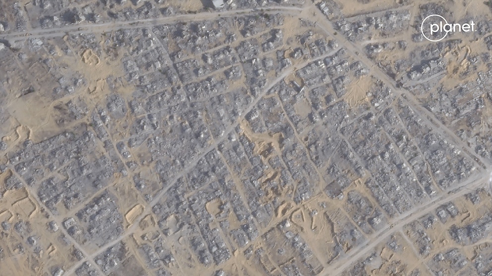
LONDON -- Since Hamas' Oct. 7, 2023, terrorist attack against Israel and Israel's military response in Gaza, an ABC News analysis of dozens of satellite images from the last two years shows the massive destruction across nearly every area of Gaza.
The images show entire towns and neighborhoods have been ravaged in Gaza, alongside key infrastructure like schools, hospitals and religious buildings.
As many as 197,000 buildings have been damaged or destroyed during the war, according to estimates in a damage analysis shared with ABC News of Copernicus Sentinel-1 satellite data by Corey Scher and Jamon Van Den Hoek of Oregon State University's Conflict Ecology lab.
Israeli Prime Minister Benjamin Netanyahu addressed the extent of the destruction in an Aug. 10 press conference with the foreign press.
"The physical destruction is not because Israel is destroying structures with people in there. That's not what's happening," he said.
Netanyahu said in the same press conference that Israel waits until civilians leave, but that Hamas operatives remain "in just about every single building," forcing Israeli forces to detonate "old APC armored personnel carriers with tons of explosives" in streets. He also said Hamas operatives "set off all the booby traps," when troops enter, "so the buildings collapse. That's why you see destruction."
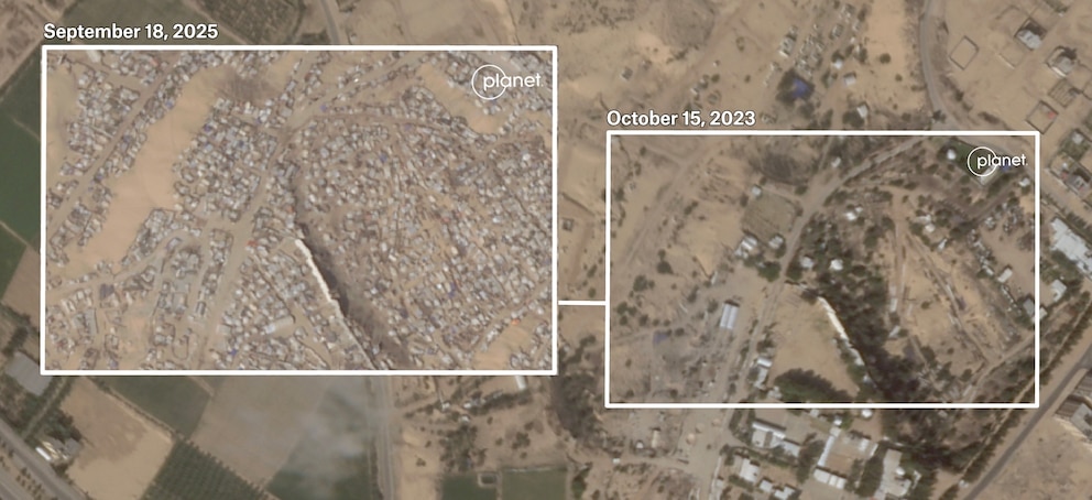
Entire town gone: Umm al-Nasser and Al-Mughraqa
Two towns in Gaza have been completely leveled. Satellite images show there are no buildings left standing in Umm al-Nasser and Al-Mughraqa. Every single structure in these towns has been destroyed, the images show.
Umm al-Nasser is a Bedouin town in the far north of Gaza. Before the war it was home to just shy of 5,000 people. An ABC News analysis of satellite images shows it was flattened by the Israel Defense Forces between March 29 and March 31, 2025.
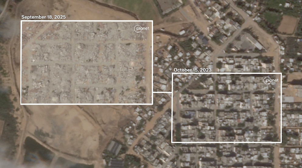
In response to ABC News' inquiries about the destruction, the IDF said the activity was in accordance with international law and was done to prevent "offensive terrorist activities."
"The village residents are scattered in several places in western Gaza City, while others have moved to the southern Gaza Strip," a public relations manager for the town told ABC News.
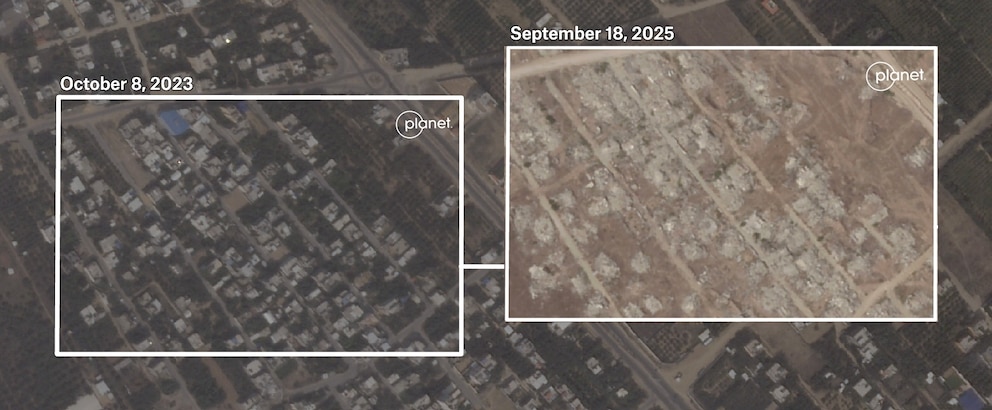
Large parts of Al Mughraqa, a town of roughly 11,500 inhabitants between Gaza City and Central Gaza, was destroyed mostly between April and August 2024, according to satellite images. During that time, Israel was in control of the area, which it calls the Netzarim corridor.
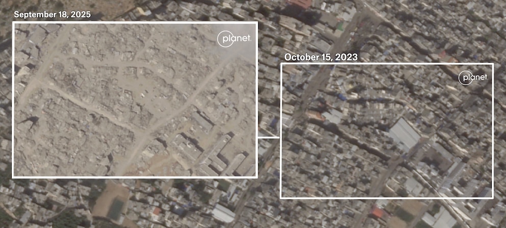
Blocks flattened in Jabalia and Rafah
In several areas that Israeli forces have controlled for extended periods of time, including Rafah, northern Gaza, and Khan Younis, buildings along entire blocks of cities have been razed altogether.
In Tal Al Sultan, the neighborhood in western Rafah, satellite images indicate nearly every building on every block has been destroyed. Often the only buildings left standing are schools.
A similar scene is visible in images of Jabalia, the city in northern Gaza, where Israeli forces have conducted numerous ground operations throughout the war.
Despite the near-total ruin, the occasional tent can still be spotted among the rubble, set up by people who had returned north during the last ceasefire to find their homes destroyed, satellite images viewed by ABC News show.
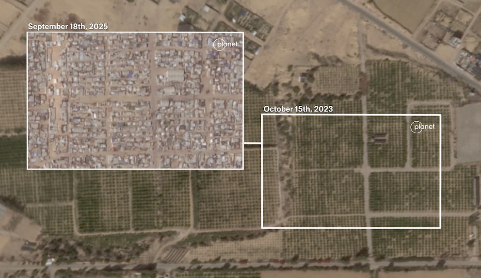
Mass displacement: Al Mawasi
The change in landscape from the mass displacement of millions of people is starkly visible in satellite images.
In Al Mawasi, miles of fields have been turned into cramped camps of thousands of tents. This is the area that Israel has designated as a "humanitarian area" where people are directed to move to avoid combat zones.
Philippe Lazzarini, the head of the UN agency for Palestinian refugees, UNRWA, said in August that services in the area are not adequate: "Hundreds of thousands of Palestinians displaced to Al Mawasi have little or no access to essential services and supplies, including food, water, electricity and tents," he said in a UNRWA statement.
Farther north in Al Mawasi, just west of Khan Younis, the thousands of tents snake their way up the coast, taking over any inch of available space, creating a semblance of a new city among the canvas, according to satellite images viewed by ABC News.
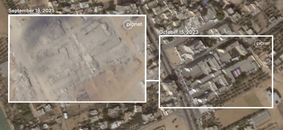
Schools destroyed Rafah and Khan Younis
An ABC News visual analysis of satellite imagery and 200+ verified social media videos shows that 88% of Gaza's schools are destroyed or damaged. At least 58%, or 318 school buildings, are at least partially destroyed.
In a statement to ABC News about the destruction of schools in Gaza, the IDF said, "There is no IDF policy to target schools or educators. Rather, Hamas' widespread and well-documented strategy of exploiting schools and educational facilities for terror activities, has required IDF activity in those areas."
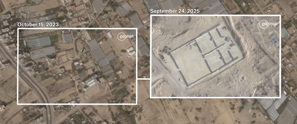
The Al-Firdaws Elementary school, west of Rafah, educated 488 students before the war, according to UNICEF data. Until spring 2024, satellite images show it sheltered hundreds of displaced people.
After the IDF took control of the area in the spring of 2024, satellite images show the school was destroyed and, over this summer, the rubble was cleared to make way for the building of an aid distribution site for the controversial American-backed Gaza Humanitarian Foundation.
In Khan Younis, five schools in a complex, which educated a total of 6,915 students, according to UNICEF, were destroyed in August of this year, satellite images show.
In a video released by the IDF, another four schools roughly two miles north of these were mined and destroyed, also in August. In the video of the destruction of those schools, the IDF refers to them as "terrorist infrastructure," and says their forces were operating against such infrastructure in the area of Khan Younis.
ABC News' Kerem Inal and Diaa Ostaz contributed to this report