Tornado watch issued for parts of the Southeast as heavy rain, snow expected in the West

A tornado watch was issued on Sunday for parts of the Florida panhandle, Alabama and Georgia.
The National Weather Service issued the watch, which will remain in effect through Sunday afternoon, as severe weather is forecast to pass through the Deep South, bringing the potential for damaging winds, large hail and heavy rain east from Brunswick, Georgia, and Gainesville and Jacksonville, Florida, into southern Mississippi.
The watch was issued around 9:35 a.m. ET and is expected to remain in place until at least 8 p.m. ET.
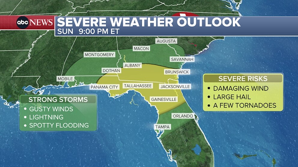
Scattered damaging wind gusts, possibly up to 70 mph, are forecast for the areas under the tornado watch.
The severe weather threat comes a day after severe storms passed through the Deep South, producing damaging winds and some hail from eastern Texas to southern Mississippi. No casualties were reported from Saturday's storms.
On Sunday morning, storms continued to track through the South and are expected to set the stage for more severe weather into Sunday afternoon and evening across the Heartland.
The highest threat for severe weather on Sunday includes parts of the Florida panhandle from Panama City to Tallahassee and Jacksonville. The severe weather is also forecast to stretch north into parts of southern Georgia and southeast Alabama, from the towns of Dothan, Alabama, to Brunswick, Georgia, as well as the region's coastal waters.

Severe storms are possible on Sunday from Mobile and Montgomery, Alabama, to Macon and Augusta, Georgia. Orlando and Tampa, Florida, are also in the path of the severe weather pattern.
Over the next 24 to 48 hours, parts of the Southeast, including Tallahassee and Tampa, Florida, and Raleigh, North Carolina, could see 1 to 2 inches of rain in areas that have been dealing with drought conditions.
Snow and rain forecast for the West
Meanwhile, a series of storms forecast to begin Sunday afternoon will pound the West from California to Colorado with very heavy snow in the mountains and heavy rain and flooding for coastal California.
The highest threat for isolated flash-flooding on Sunday is expected to occur from south of the San Francisco Bay Area to Los Angeles.
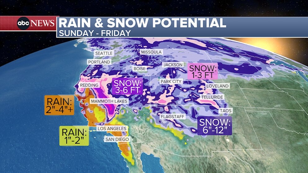
From Sunday through Friday, some areas in California could see from 3 to as much as 6 inches of rain, threatening to trigger flash-flooding and debris flow.
On Monday, scattered flashing flooding could possibly occur from Big Sur down to Los Angeles and San Diego.
The storms are also expected to pack gusty winds and heavy mountain snow. In addition to heavy rain on Monday, some areas along the Central and Southern California coasts are under wind alerts for gusts between 45 and 60 mph. These winds, combined with heavy rain that will loosen the ground, may produce damage and power outages.
California's Sierra Nevada Mountains could see a whopping 3 to 6 feet of snow this week, while the Rocky Mountains could also see several feet of fresh powder.
Parts of the Sierra Nevada are under winter storm warnings for anywhere between 1 to 7 feet of snow, depending on elevation, with the higher elevations expected to see the higher end of this range.
The snow comes amid a record-low amount of snow in the West this winter.
Light snow forecast for the Northeast
The same storm system hitting the Deep South is expected to move through the mid-Atlantic and brush the Northeast, producing light snow on Sunday night and into Monday morning.
Some flurries could begin as early as 7 p.m. ET Sunday in parts of the Northeast and become noticeably heavier around 8 p.m. ET as the system moves into eastern Pennsylvania and southern New York.
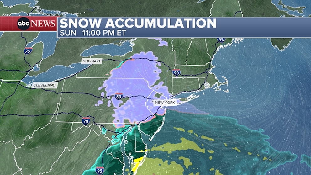
Harrisburg and Philadelphia, Pennsylvania, and New York City are expected to see snowfall sometime between 9 p.m. and 11 p.m. on Sunday.
The snow is expected to continue in places like New York City and Philadelphia overnight and into Monday morning, possibly leaving slick roadway conditions for Monday morning’s commute.
An inch or more of fresh snow could fall on eastern Pennsylvania and lower New York, including parts of the I-95 corridor from Philadelphia to New York City.